Travels of the Jabberwocky (If you want to see our position then go to : www.shiptrak.org and enter radio call sign KB9RPI.) Copyright 2006 to 2012 All Rights Reserved

Tuesday, June 24, 2008

St. George's, Bermuda, Tuesday, 24 June 2008

We are getting ready to leave for the US tomorrow morning. We have put off departure for several days due to bad weather to our north.
With the weather conditions forecasted it looks like we may end up back in the Chesapeake before going to New England. There are an endless stream of low systems coming through the north east part of the US.

The Flats, Bermuda Monday, June 23, 2008

Monday we spent time at the Island's Acquarium/Zoo. Here are a few pictures of the interesting animals there.


Saturday, June 21, 2008

St. Georges, Bermuda Saturday, June 21, 2008

We have been here a week already. It is hard to believe! The long promised front finally came and it has been rainy on and off for the last couple of days. Here we are having lunch at the Frog and Onion Pub when we visited the Naval Dockyards several days ago.


We went to Hamilton yesterday, Friday, to see the Bermuda Underwater Exploration Institute. It has an incredible collection of sea shells put together by a Mr. Jack Lightbourn throughout his life and made available to the Institute. It also had an interesting deep sea "ride" on a simulator. We dove to 10,000 feet and in the end had to evacuate due to an attack by a giant squid!!


A carved shell.


A new design deep dive suite.


A diving "bell" developed in the 1600's.

Thursday, June 19, 2008

St. George's Thursday 19 June 2008

We spent several days touring the Island of Bermuda. Visited Hamilton, including a walk around the city seeing The Royal Yacht Club, the Art Museum and Historical Society. Today we took the ferry to The Navy Dockyards and spent several hours at the fort, seeing the 500 year story of the island.

We are doing Internet at the Post Office as we moved our boat to a different part of the harbor and we currently do not have Internet access.

Monday, June 16, 2008

St. Georges, Bermuda Monday, June 16, 2008 - Queen Elizabeth's Offical Birthday


Today is a holiday in celebration of Queen Elizabeth's Birthday. Bermuda has had its own parliament since the early 1600's, but continues to be a British Territory with a governor appointed by the Queen. The governor has limited power and can take action only under extreme circumstances. There has been occasional referendum for independence and the most recent outcomes are still in favor of remaining a territory.

The event is celebrated by a small sailboat race with the entire local motor boat fleet following behind. Many of the boats decorated, loaded with folks and playing music.


The entrance from the sea to St. George's Harbor is through a narrow cut, Town Cut, where a section of hill was cut away. Many of the cruise ships just fit as the following pictures depict.


The training ship for the Maritime School for the State of Maine was in port. She departed this morning.


Going through Town Cut.


Today is quite windy so we may stay on boat and the dingy trip to shore could be a bit wet. Also the cruise ship just deposited quite a few hundred passengers in the town.


We had been hearing a rooster on shore the last few days. In our walkabout yesterday I think we found the culprit

Sunday, June 15, 2008

St. George's, Bermuda Sunday 15 June 2008

Here is a view of St George's harbor from the a location by Fort Georges on Rich's Mount the highest point on this end of the island at 256 feet above sea level.


The facilities of Radio Bermuda are also located here. Their services manage all shipping activity in and out of Bermuda. As we approached the island on Friday we contacted them when we were 30 miles out and they provide navigational information and clear you to enter the harbor.

One of the several large cannon that were used to prevent unwanted visitors access to the island. The fort was built here in 1788.

We finally got off the boat and into town after a day of resting from the trip. Here is Joyce in the town square stocks.

And Gordon at another of the fortifications protecting access to the island.


Here is Jabberwocky (in the foreground) at anchor.


A local residence and one of many lovely homes in the area.


PS: We actually have a wireless Internet connection on the boat. One of the local boat yards provides the service free. Also, do not complain about high diesel prices. We checked the pumps at the town fuel dock and it was $2.07 per liter (3.785 liters per gallon) this works out to $7.83 per gallon. Water is dear here and they charge $0.15 gallon as well.

Saturday, June 14, 2008

St. Georges, Bermuda Saturday, June 14, 2008


We arrived in St. Georges Bermuda last evening around 7 pm. Checked in with customs and immigration and then found an anchorage for Jabberwocky.


This is a chart of the island, which is the top of an extinct volcano. The depth of the water a few miles away is 12,000 feet.


This is the view of the east end of the island as we were approching the channel to the inner harbor.


This is a view of the town just a few hundred yards from where we are anchored.


Sunday 6/8/08 to Friday 6/13/08 Hampton, VA to St. Georges Bermuda

These comments are from emails sent by HF radio during our voyage.

June 9
Lat 36 Deg 31.1 min
Long 74 Deg 53.1 min

We have traveled about 86 nm so far today. Very light winds and have had to motor. Winds finally up to 12kts and will start running under sail only shortly.

We will send more tomorrow. We should be in the Gulf Stream mid-day tomorrow.

At 1300

Lat: 35 deg 56 min N
Long: 73 deg 30 min W

We had a busy night. The winds finally picked up after sunset and we had 15 to 17 with gusts to 22 during the night. Around sunset the Research vessel Nar pasted close by heading to waters off Bermuda for a few weeks and indicated they would be landing in Bermuda around th 27th of June.

Around 2 am Joyce was on watch and woke me up due to a call on the radio. It turned out to be a Navy warship cruising the area. We spent about 20 minutes shifting our course so they could realign their position to avoid another vessel that they could not contact.

We generally check the radar every half hour. This morning around 6 am while we thought we had decent visibility we saw a ship only about 2 miles away approaching rapidly. It cleared the fog about 1.5 miles off our port quarter. We were able to contact him and he altered course.

The wind died again an we started our engine around 1030 am this morning. We are very definitely in the middle of the Gulf Stream as I prepare this note with the current pushing us NE around 2.5+ knots. We hope to be east and clear of the Stream toward midnight.

Another hot day with the temp at 93 and little wind.

June 10

Lat: 35 deg 20.9 min N
Long: 071 deg 46.7 min W

We had a night of slow going. We thought we were through the Gulf Stream but a nasty 2 knot current against us and light winds made for little progress. The current finally abated this morning around 7 am and the winds seem to be consistent right now with the forecast of 10 knots from the southwest. We are making progress again.

June 11

Lat: 34 deg 50.9 min N
Long: 70 deg 26.4 W

Generally light winds during the day made about 110 miles. We need to run the engine for a few hours to keep up forward progress when winds get really light. With the calm seas we can run on really low RPM and seem to be getting reasonable fuel consumption. Best estimate is we used about 25 gal so far. Not bad considering that we motored pretty steady getting out of the Bay.

There is no traffic at all out here. Once we left the Gulf Stream the radar is absolutely blank. Probably will not see anything until Bermuda. We work with a Canadian fellow by the name of Herb that does weather forecasting with folks traveling in the North Atlantic. He comes on every day at 1900 GMT. We each take turns talking on the HF SSB with him. Right now there seems to be about 25 boats spread from the US East Coast clear across the Atlantic. Herb has been doing this as an avocation for years.

There is a front coming through sometime Thursday. This will cause our southwest winds to shift to the north/north west. We are a close to half way at this point. The weather was actually comfortable today.

June 12

Lat: 34 deg 14.1 min N
Long: 068 deg 26.3 W

We continue to make progress toward Bermuda. The GPS suggests that there are 230 miles or so remaining. The light winds continue so most of the day was spent motoring yet again. We had a strong unfavorable current for about 8 eight hours today that turned out to be a big warm water eddy. These are spun off by the Gulf Stream as spin clockwise (there is also a cold counter part that does the opposite).

Right now I am under sail with 6 kts of wind moving at 3.5 kts giving the engine a break so I can check the oil level. Even though it is new the Yanmar engines are designed to actually consume quite a lot of oil so I need to check it every 12 hours or so. It needs to be stopped for about 10 minutes. I think we are actually going to make 60% of this trip on engine power.

There is a front going through today, Thursday, that should bring northwest or even better north to north east wind that will be favorable for the final leg.

We did actually see a cruise ship this morning around 7 am. Visibility was very restricted. Joyce just came on watch and was checking the radar that there was this blip off about three miles that finally appeared on our starboard heading northwest.

2330

Lat: 33 deg 23.0 min N
Long: 66 deg 10.8 min W

Calm clear night with good moon light. The temp is in the mid 70's and the visibility is excellent. We are motoring as usual and are about 110 miles out of Bermuda. We should get some wind in the morning from the northeast as a small cold front passes. We anticipate arriving in St. Georges around 7 or 8 tomorrow evening and will clear customs at that time. I am finding with propagation conditions that I cannot send updates during daylight hours very reliably.

We will contact you by phone probably on Saturday.

June 13

The front came through and the winds are to the NE at 15 as forecasted. Arrival still anticipated late afternoon with distance to go approx 60 miles.

Lat: 33 deg 01.9 min N
Long: 65 deg 25.8 min W

Sunday, June 08, 2008

Sunday, 8 June 2008 Coastal Virginia 2:40pm


The last buoy, "CB" on the outbound channel. We are still waiting for the promised wind. Hope it arrives by evening.
We are just about out of Internet range at 10 miles off shore.

Saturday, June 07, 2008

Saturday, June 7, 2008 Hampton, VA

This is a Gulf Stream chart of the mid-Atlantic coast. You can see our planned course to Bermuda. This is called a rhumbline course. Our actual course will vary from this depending on the winds and currents. (Chart source: oceanography.navy.mil)
The distance is about 670 nautical miles.


The weather reports for the next four days continue to be favorable so we will be leaving in the morning around 8 am. The winds are forecasted to be from the southwest to west at 10 to 15 building on Monday to 15 to 20. With good radio propagation conditions you should be receiving updates while we travel. We will top off our fuel and water tanks first thing in the morning and head to the point of departure at the Chesapeake Bay entrance about 20 miles east.

Friday, June 06, 2008

Friday, June 6, 2008 Hampton, VA

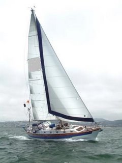
We are now anchored out in Hampton harbor in a really confined space between the yacht club and a private marine. Not much room to swing as the wind shifts. This is a one boat spot fairly deep spot that is hard to get. In the photo you can see the local harbor side hotel and some of the town docks.


A traditional work boat that appears to have been restored. We are anchored just off the main channel.


We are still waiting on the winds to pick up off shore. Sunday is looking quite possible with winds offshore shifting back to southwest at 10 to 15 knots increasing later to 20. We want two solid days of south to south west winds to travel out the 160 miles or so to get across the Gulf Stream.
Thank goodness that Hampton is relatively close to the ocean. The southeast wind is keeping the temperature down to 85. As with yesterday the temps inland VA are around 95. There is a big fire burning in North Carolina and if the wind shifts more to the south here we get the odor from this fire which is 75 to 100 miles away.
We are passing the time checking weather reports (probably too much information) and getting our blowup dingy organized. We got it in the water this morning and all set up and found a leak through the drain plug in the stern. So it had to come out and get caulked a bit. Its back in the water again and we are keeping an eye out for further leaks.

Thursday, June 05, 2008

5 June 2008 Thursday - Hampton Harbor

Well the weather person did not come through for us and the winds died due to a high pressure off the coast. We moved off the dock and are now anchored in Hampton Harbor. Better here than sitting on a rocking boat without wind. We are keeping an eye on Sunday for the winds to pickup from the south west.

There are real summer conditions here with the temperature in the mid 90's and high humidity. Apparently it is much hotter in land Virginia with temp's in over 100.

Wednesday, June 04, 2008

Wednesday, June 4, 2008, Hampton, VA

Hi All,

Finally on the move again. Leaving in the morning for Bermuda, which could be a 7 to 10 day trip because light winds are in the forecast. Our family will be receiving emails via High Frequency Radio broadcasts if conditions are good and will be updating the blog with that information. We will also be updating our positions.

Gordon & Joyce