Sandy Hook to Lewes, DE (Entrance to Delaware Bay) 1 September 2007

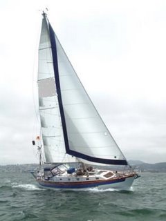
We left Sandy Hook, (Atlantic Highlands Harbor) at 9:30 a.m. on Friday August 31 and arrived at a harbor of refuge called Cape Henlopen in the lower section of Delaware Bay at 9:30 a.m. on Saturday the first. A total of 126 nautical miles. We had hoped to do an additional 50 miles up Delaware Bay to the C and D Canal ( Delaware-Chesapeake) but the wind ( up to 30 knots and tide and waves) were not in our favor to go up the Bay. We had quiet seas most of the night but the wind picked up and we had following seas once we got into Delaware Bay past the shoals around Cape May the waves and wind started to build. In fact when several container ships looked like "buildings rather than ships" because the waves we bouncing us around so much and we decided to go to Plan B and head for Penlopen Harbor of Refuge. We are staying here until the 2nd and then proceed up the Bay to the canal and then stop just short of the Chesapeake Bay and Sunday. This is a picture of the Fast Ferry to Manhattan that we passed before we rounded the Sandy Hook out to the Atlantic Ocean.

A passingg freighter as we were proceeding along the New Jersey Coast south to round Cape May and proceed into the Delaware Bay.

This was sunset on the Atlantic Ocean. It had been hazy all day with predictions of clearing but increased winds and a weak cold front coming in. Close to sunset the clouds dissipated for this picture of the setting sun. We stayed pretty close to the New Jersey shoreline and saw many of the old Victorian houses and beach resorts. Beautify low lying sandy beaches were evident along the coast.

This picture was taken around midnight about three miles off the coast of Atlantic City. I had hoped it would be a clearer shot but the large following seas and the camera just couldn't capture the view of the city I had hoped to capture. It was a beautiful night with a full moon shining on the ocean and the coast line twinkling with the lights along the coast. We saw many fishing boats but as we progressed further south we met several tug boats and barges being pulled north toward NYC. We frequently check the U.S. Coast Guard Navigation Rules to see the light patterns on tug boats, barges and freighters so we can determine what we are approaching. I never hesitate waking up Gordon if I am on watch so he can "check it out" while we skirt around any traffic although I am gaining more confidence in identifying the ship traffic its nice to have the Captain check it out if I am in doubt!
 Once we passed around Cape May New Jersey into the Delaware Bay, dawn had arrived and we no longer had following seas but head winds and choppy seas against the tide. There were several large structures that looked like "buildings" but in reality were large freighters so we turned into Cape Henlopen as a harbor of refuge since we did not want to battle these waves for 50 miles! We anchored by this inner break wall and by 5 p.m. the waves were calmer so I took this picture of the break wall. The Cruising the Chesapeake 3rd edition says "
Few people cruise the Delaware Bay for pleasure-it is something to endure to reach the Chesapeake Bay - the 50 mile passage with tide range of 5+ feet and resulting currents together with shallowness of the bay can make some fairly uncomfortable conditions on the bay" true to form!

These passenger ferry boats were not far from the break wall and take people every hour or so across the bay. Too bad we couldn't attach our boat and hitch a ride!
posted by Joyce and Gordon at 5:55 PM
![]()

0 Comments:
Post a Comment
<< Home